High School Textbook Labels Upper Peninsula Map Incorrectly
Back in February we reported on one of the ugliest maps we’ve ever seen of the Upper Peninsula (or Michigan for that matter). We asked all of you if you knew of any maps that were similar. Many times I’ve heard reports of maps that didn’t include the Upper Peninsula, mislabeled it, and various other scenarios.
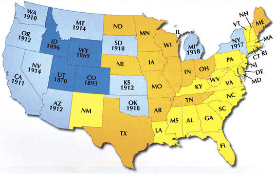
On November 8th, the Daily Press of Escanaba reported another such story titled, “U.P. loses its identity”.
The earlier map we mentioned actually did have some justification. The outline they used is the actual state outline of Michigan which extends into the middle of Lake Superior, Lake Michigan, and Lake Huron. Now I would like to see the justification for this example.
As reported by the Daily Press the map (pictured above) was noticed by social studies high school students at Escanaba Area High School.
As you can see in the map every state is colored in and labeled with the two-letter abbreviation. However, for starters, the Upper Peninsula isn’t colored in like the rest of Michigan. And why is it labeled “IL” for Illinois!?!?
The students took it upon themselves to take action.
“We were studying suffrage before the Depression and it had a map of all the states and the U.P. was not included. We thought it was a little bit degrading, like we weren’t part of the U.S. It’s kind of ridiculous.”
According to the article the students have written a letter to the publication company informing them of the error and went further to include some information about the Upper Peninsula (which is 1/3 of all the land in Michigan by the way). The book is titled, “United States History: Modern America (Michigan edition)”
Does anyone else have more examples of unfortunate Upper Peninsula maps?
A shoutout to Katie M. for sharing this article with us. Thanks Katie!


