Just in case you didn’t know, 906 is the only area code for the entire Upper Peninsula of Michigan. In addition, 906 is the largest area code in Michigan.
On March 19th, 1961, area code 906 was created as a split from what was then area code 616. Currently, according to Wikipedia, the area code is not expected to be exhausted until 2042.
Since 2012, September 6 has been designated as 906 Day for its resemblance to the date 9/6. On 906 Day, Yoopers and Upper Peninsula fans alike, are encouraged to take a sauna, buy a pasty for a friend, play a game of cribbage, go for swim in Lake Superior or Lake Michigan, or pay for the person behind you at the Mackinac Bridge.
The Upper Peninsula is full of unique roadways offering scenic views. Some sections are straight as an arrow (lookin’ at you Seney Stretch), one is the longest state highway in Michigan, another is the only state highway in the United States not to allow cars (I’m sure you can guess which). It’s also said that Copper Harbor is the furthest place you can live from an Interstate in the continental United States, a distance of 251 miles from I-39 in Wisconsin. If you’re new to the Upper Peninsula, don’t be fooled, these are not multi-lane divided highways, most are entirely small, two-lane highways.
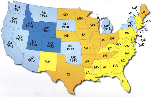
Today is Michigan’s 186th birthday! To celebrate we’re giving a bit of history lesson. We hope you’ll learn as much we did putting this together.
We’ve compiled highlights from every year since Michigan’s admittance into statehood in 1837. But as we know, this just a small piece of Michigan’s rich history. Please share your additions in the comments below.
Things to do in Michigan today…
Eat a pasty, or a coney dog
Visit Lake Superior, Lake Michigan, Lake Huron, or Lake Erie
Visit Presque Isle, or Belle Isle
Drive across the International Bridge, or the Ambassador Bridge, or the Mackinac Bridge, or the Portage Lift Bridge
Cheer for the Huskies, or the Wolverines, or the Wildcats, or the Spartans
Watch Escanaba In Da Moonlight, or 8 Mile.
Stay awesome, keep exploring, and do all the fun things in Michigan.
Two wrongs may make a right, but two meteor_wrongs_ certainly don’t make a meteo_rite_.
And here’s why.
Well, first — let’s rewind.
To one day in 1889 when a six-year old boy named Peter Peterson (yes, this was actually his name) was helping his father clear rocks from a field near Iron River.
Things were proceeding as usual (I’m assuming) when little Peter noticed that one rock was much heavier than others of the same size. He showed the 3.13-pound whopper to his father who told him to toss it like the others.
This post and photos brought to you by two friends of Yooper Steez, Allison Rueff (a native Yooper from Marquette living in Cincinnati) and Kate Rose (from Novi living in San Francisco), former MSU roommates who finally made it up to Isle Royale after years of talking about it. It lived up to all the hype, and they praise God for whatever topographic mistake has yielded this Michigan treasure.
Today we salute you, Mr. Shakyhands-Cartographer-That-Gave-Isle-Royale-To-The-U.P.-Instead-of-Canada. Some people say it was the foresight of our founding father, Benjamin Franklin, who gave us Isle Royale under the Treaty of Paris. But we know better. When you were employed to draw that boundary in 1783, your pencil moved gracefully from Sault Saint Marie and across Thunder Bay…and suddenly you had to sneeze. And in that nasal explosion, you unwittingly gave Michigan a spot of pristine wilderness that would be cherished for generations. Mostly by generations of moose, but hey – that’s the U.P.
For years people have debated what northern Michigan actually means. Simple asked, what point does Michigan become Northern Michgian? Entire clothing lines of t-shirts and hoodies have made thousands of dollars off the “Up North”. This language is more common Traverse City area, rather than the Upper Peninsula.
But we ask, where is Northern Michigan University? In Marquette, on the shores of Lake Superior, far north of Makinac Bridge. Despite this, you have to go 136 miles south of the Mackinac Bridge to find the southern most claim of where Michigan’s “North” begins.
Michigan’s Upper Peninsula is a vast region. By the way, did you know that the Upper Peninsula is wider than the Lower Peninsula is tall?
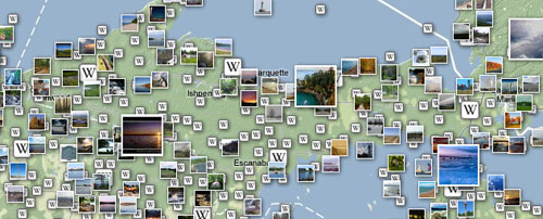
I love exploring Google Maps and finding aerial views of my favorite places in the Upper Peninsula as well as the rest of the world. Here are my top findings from the Upper Peninsula. If you would like to add any more just leave a comment. Click the photo to open the map in a new window for a higher resolution image and to explore that area.
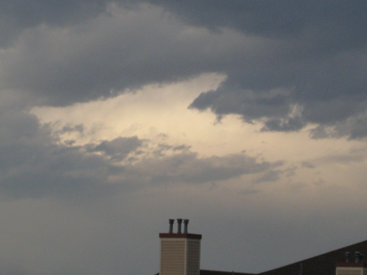
This week Yooper Steez received an incredible photo in the our e-mail box. Our new friend Joe from Houghton (who is now living in Littleton, CO) found the Upper Peninsula in the sky above him one day.
“This picture has not been edited and is proof that God is a Yooper. ”
-Joe
Thanks for the great submission Joe. Strangely, this is actually a better map of the Upper Peninsula than some other maps out there.
It’s been talked about plenty on the site, but this is the first post of a map where the Upper Peninsula is completely missing. We have all seen maps like this before, sadly. And despite the recent Upper Peninsula bill it will probably continue to happen. Some would argue that it’s a good thing, so not too many people move to the U.P.
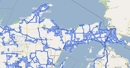
Last September I reported, from this same seat, that I saw a Google Street View car drive by outside my window. At that point I knew that Google Street View was finally coming to the Upper Peninsula. Being the nerd I am, I was very excited. I was also very curious to see what depth of they visit the Upper Peninsula since it is a rural population.
Several months ago while sitting in this location I noticed a funny looking car drive by my apartment window. I followed up with my initial hunch with some research and came to the hypothesis that it must have been a Google Maps Street View car.
It’s possible that my hypothesis was wrong. Several others agreed to seeing the same car, but no evidence yet.
I decided it was time to follow up on the status. In the last several months Google Street View has expanded their range dramatically. However, it hasn’t quite mapped out the Upper Peninsula. But, they have mapped out I-75 and gone over the Mackinac Bridge.
Tourist season is coming! Time to travel, camp, go sight-seeing and vacation in the Upper Peninsula. If you’re a local don’t forget to be a tourist in your own town this summer and visit all the places you’ve read about but have never visited. For tourists and locals alike we put together a list of resources to help you plan your Upper Peninsula vacation, road trip, or afternoon drive.
The Upper Peninsula will now be required to be included on all official state maps and publications.
Can you imagine a state where 1/3 of the state is not included on the map in official state documents? We recently mentioned a bill introduced by State Rep. Michael Lahti (D-Hancock) which seeks to fix this problem.
Now it seems silly to me that this has to be an official bill. Some “trolls” have stated that the Yoopers are whining. But the fact that a state isn’t wholly represented within state documents seems absurd. Our legislature shouldn’t have to spend time on petty little bills like this that shouldn’t have been needed in the first time. Apparently the house of representatives agreed.
In the last few weeks both the Daily Mining Gazette and WLUC TV6 have published articles on State Rep. Michael Lahti’s (D-Hancock) efforts to have the Upper Peninsula represented Michigan images published by the State of Michigan.
Back in February we reported on one of the ugliest maps we’ve ever seen of the Upper Peninsula (or Michigan for that matter). We asked all of you if you knew of any maps that were similar. Many times I’ve heard reports of maps that didn’t include the Upper Peninsula, mislabeled it, and various other scenarios.
On November 8th, the Daily Press of Escanaba reported another such story titled, “U.P. loses its identity”.
Last November I stumbled across a map on Google images. It took but a second of thought to notice that it was the ugliest rendering of Michigan that I had ever seen on a map. The Lower Peninsula was pretty horrible, but the rendering of the Upper Peninsula was even worse! For anyone who holds the U.P. close and dear to their heart, you may have to sit down before looking at this.